Tropical Storm Florence Forms in the Atlantic Ocean
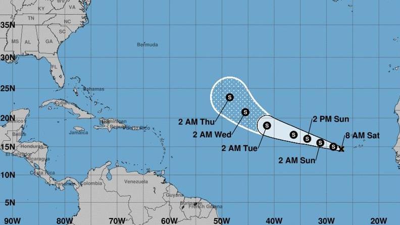
Tropical Depression 6 has upgraded to Tropical Storm Florence on Saturday morning, making it the sixth named storm of the 2018 hurricane season.
A tropical storm warning is in effect for Cabo Verde Islands of Santiago, Fogo andBrava, according to the National Hurricane Center. There aren’t any coastal watches or warnings in effect.
The storm is moving west-northwest at 14 mph and is a few hundred miles west of the Cabo Verde Islands. A 5 a.m. NHC discussion states that it should keep this track for the next two days, and forecasters expect by day 5 for the storm to slow down and shift in a northwest direction.
The highest sustained winds clocked in at 40 mph, with even stronger gusts. Tropical storm force winds stretch out 35 miles from the storm’s center. About 1 or 2 extra inches of rain are expected in the southern Cabo Verde Islands on Saturday.
A second system in the Atlantic, a tropical wave hovering north of Hispaniola, could cause extra rain in South Florida early next week. The wave has a 10 percent chance of forming within the next two days and 40 percent chance of forming in five days.
According to the National Weather Service in Miami, the wave could produce periods of heavy rain, localized flooding as well as isolated tornadoes and waterspouts between late Sunday and early Tuesday.
The system could move across the northern Gulf of Mexico coast between the early and middle part of next week.
Source: The Palm Beach Post