Tropical Storm Lee Starts Cruising thru the Atlantic Ocean
A newly formed tropical depression is expected to become Tropical Storm Lee on Friday.
The depression is one of two weather systems that have emerged from the coast of Africa and are being monitored by the National Hurricane Center.
All this as Tropical Storm Jose continues to circle in the Atlantic, possibly posing a threat to portions of the U.S. east coast next week.
These developments are a raw reminder that as Florida tries to recover from Irma, hurricane season is not over.
“The peak of the hurricane season is mid-August through late October, and conditions remain favorable across the Atlantic basin for systems to form and strengthen,” said National Hurricane Center spokesman Dennis Feltgen.
Both of the systems that have emerged off Africa are still thousands of miles from South Florida.
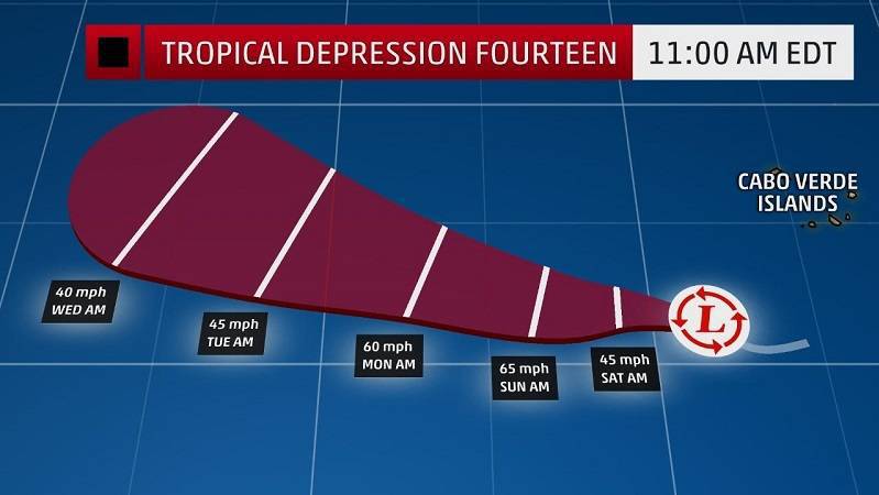
The one that is Tropical Depression 14, and ready to become a tropical storm, is actually still closer to the coast of Africa than is the other system.
Late Friday morning, the depression had maximum sustained winds of 35 mph and was heading toward the northwest at 10 mph.
“The depression is forecast to become a tropical storm later today,” forecaster Eric Blake wrote in the 11 a.m. advisory.
The second system, a tropical wave, is being given a 50 percent chance of developing over the next two days and a 90 percent chance of developing over the next five days.
It’s too early to determine what impacts, if any, either of these systems would have on the U.S. or elsewhere. The National Hurricane Center’s latest tropical weather maps show both as heading generally toward the Caribbean. It’s not possible to forecast with any certainty where they would head beyond that. Both are still over 3,000 miles from South Florida.
Still, these two systems are showing early signs of becoming typical, peak hurricane-season storms. Called Cape Verde storms, these cyclones form from winds blowing off the African coast — often near the Cape Verde Islands, the Atlantic’s hurricane incubator.
After forming in the far Atlantic they march westward toward the Caribbean, gathering strength as they make the dayslong journey. They tend to travel north, sometimes toward the United States. Sometimes it’s a hard right turn, other times it’s a gradual drift.
“A common track runs from the far eastern Atlantic toward and onto the U.S.,” Feltgen said, referring to the cyclones that tend to form around this time.
So far this has been a busier-than-usual hurricane season, but it remains to be seen if Florida will be hit by others after Hurricane Irma.
“Remember 2004 and 2005? Florida was hit with several hurricanes in each of those years, including Wilma in October 2005,” Feltgen said. “We still have two and half months to go in the hurricane season, so it is important to remain vigilant and prepared.”
As for Jose, a reconnaissance flight was heading toward Tropical Storm Jose to determine if it has reached hurricane strength.
Late Friday morning, Jose was about 360 miles northeast of the Bahamas with maximum winds of 70 mph as it moved slowly toward the northwest at 9 mph.
The long-range forecast indicates that Jose could be approaching the coast of North Carolina on Monday and then remain very near the Eastern Seaboard through Wednesday.
Source: The Sun Sentinel