Hurricane Beryl Remains at Category 5 as it Roars toward Jamaica
Hurricane Beryl has intensified overnight after causing extensive damage and power outages across the southern Windward Islands. Now pushing further into the Caribbean Sea, the storm is targeting Jamaica and has triggered warnings in Haiti, the Dominican Republic, and the Cayman Islands. This has heightened concerns among residents along the U.S. Gulf Coast, who are closely monitoring the storm's path.
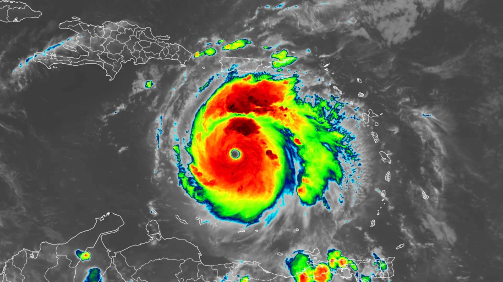
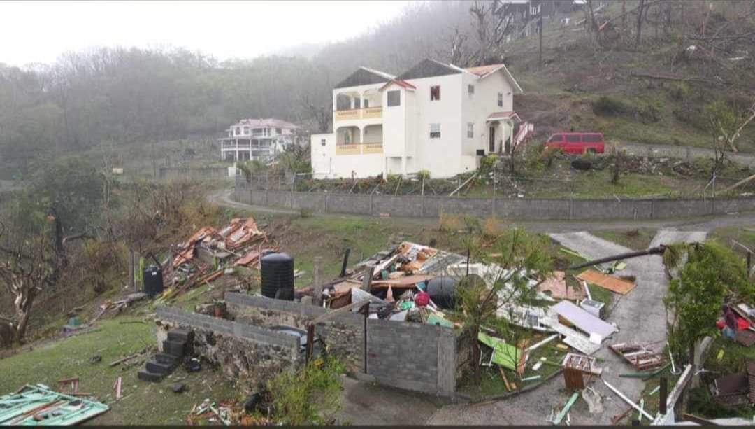
Late Monday, Hurricane Beryl escalated to Category 5, with sustained winds of 165 mph and higher gusts, becoming the earliest Category 5 hurricane in the Atlantic basin and only the second to occur in July. The storm made landfall on Carriacou Island in Grenada with 150 mph winds, causing at least one death and widespread devastation across the Grenadines and St. Vincent. After re-emerging into the Caribbean Sea, Beryl strengthened again and is expected to remain powerful as it moves westward this week.
However, Beryl's high intensity may be short-lived due to unfavorable wind conditions expected in the Caribbean. On Wednesday, the National Hurricane Center predicts Beryl will bring life-threatening winds and storm surge to Jamaica. As of 8 a.m. local time, Beryl was located 300 miles southeast of the Dominican Republic and 625 miles east-southeast of Kingston, Jamaica.
AccuWeather experts predict the U.S. will likely avoid direct impacts from Beryl but caution residents to remain vigilant. Lead Hurricane Forecaster Alex DaSilva noted that the storm is expected to move westward into Mexico but could potentially impact the Gulf Coast if the high pressure across the Southeast weakens. Jamaica's government has issued a hurricane warning, and tropical storm warnings are in effect for parts of the southern coasts of Haiti and the Dominican Republic.
The hurricane center forecasts storm surges in Jamaica of 3 to 5 feet above normal tide levels and rising water levels of 1 to 3 feet along the southern coast of Hispaniola. Rainfall of 2 to 6 inches is expected in parts of Hispaniola from Beryl's outer bands. Beryl's maximum sustained winds reached 160 mph Monday night, maintaining its Category 5 status as it moved through warmer-than-normal Caribbean waters.
Forecast confidence in Beryl's projected path is low, with a wide range of potential outcomes. National Hurricane Center specialist Philippe Papin noted the uncertainty regarding Beryl's structure and intensity as it approaches the Yucatan. Conditions in the Gulf of Mexico are not favorable for restrengthening if Beryl moves back over the Gulf. The strength of the high-pressure ridge over the Gulf and its potential contraction will determine if Beryl can turn northward.
As Beryl approaches Jamaica on Wednesday, its winds are expected to decrease to 110 mph, just below Category 3 status. Despite the downgrade, dangerous winds and devastating rains of 4 to 8 inches, with isolated areas receiving up to 12 inches, are forecasted. Residents and visitors in the Cayman Islands, Belize, the Yucatan Peninsula, and the Gulf are advised to closely monitor Beryl, which is expected to be downgraded to a tropical storm by Thursday evening.
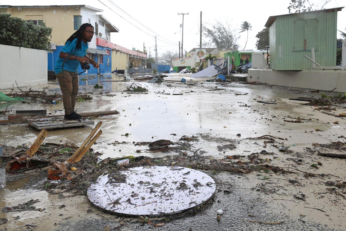
In the eastern Caribbean, residents have been preparing for the hurricane by boarding up windows, stocking up on food, and fueling their cars. Significant damage has been reported in St. Vincent, including roofs ripped off buildings and power outages across Grenada. At least one death was confirmed in St. Vincent and the Grenadines, with more fatalities possible. Prime Ministers Ralph Gonsalves of St. Vincent and Dickon Mitchell of Grenada have been coordinating damage assessments and relief efforts.
In Kingston, Jamaica, residents remain relatively calm despite the approaching hurricane. Waiter Welton Anderson shared that Jamaicans typically wait until the last minute to panic, reflecting a sense of familiarity and resilience in facing such storms.