Pacific Warming Offers Caribbean Reprieve: El Niño to Dampen 2026 Hurricane Season
Meteorologists are forecasting a notable shift in the Equatorial Pacific that could provide the Caribbean with a much-needed reprieve during the 2026 Atlantic hurricane season.
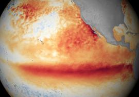
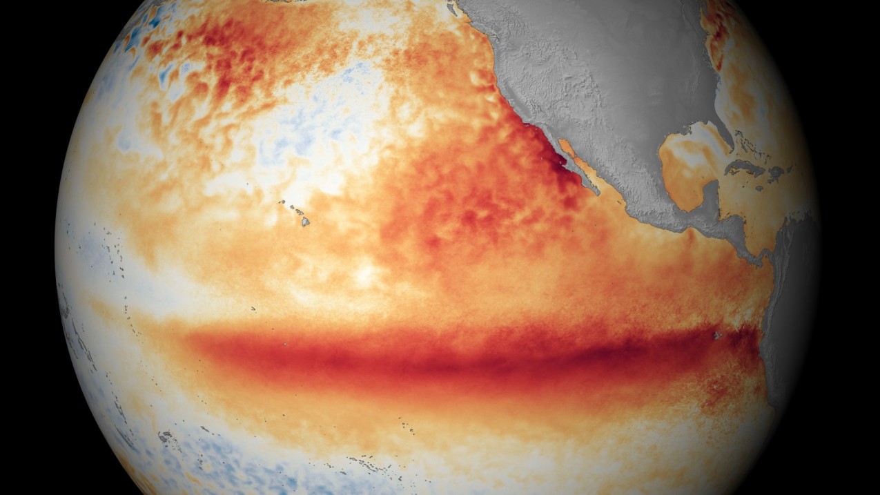
After a period of heightened tropical activity in recent years, the emergence of a robust El Niño event is expected to act as a natural deterrent against the formation of major storms. While sea surface temperatures in parts of the Atlantic remain high, the atmospheric changes triggered by the warming Pacific are likely to dominate the seasonal narrative.
The primary mechanism behind this cooling trend is vertical wind shear. As the Pacific waters warm, they alter global air currents, strengthening upper-level winds that sweep across the Caribbean Sea and the tropical Atlantic. These powerful winds essentially tilt or "decapitate" developing tropical depressions, preventing them from organizing into the symmetrical, rotating structures required for intensification. For the Caribbean, this typically translates to fewer named storms and a significant reduction in the probability of major hurricanes reaching land.
According to the latest data from Colorado State University and the World Meteorological Organization, the 2026 season is projected to feature activity levels approximately 75 percent of the long-term average. Forecasters anticipate roughly 13 named storms, which is a slight dip from the historical mean. More importantly, the number of major hurricanes—those reaching Category 3 or higher—is expected to be limited to just two, a sharp contrast to the hyperactive seasons fueled by La Niña conditions in the past.
Despite the favorable ENSO transition, experts warn that the Caribbean is not entirely out of the woods. Atlantic sea surface temperatures in the western basin are still hovering above normal levels, providing a reservoir of thermal energy that could fuel "homegrown" development in the early months. El Niño is expected to reach its peak strength during the latter half of the season, meaning the threat level may remain elevated through June and July before the wind shear becomes a truly dominant suppressing force in the autumn.
Furthermore, the influence of the Bermuda High—a semi-permanent high-pressure system—will be a critical variable to watch. If this system remains positioned similarly to previous years, it could act as a steering mechanism, pushing any surviving tropical cyclones away from the islands and toward the open sea. However, the interplay between atmospheric stability and shifting jet stream patterns remains a complex puzzle that meteorologists continue to monitor as the season approaches its official start.
Residents across the Caribbean are being urged to view this forecast as a "welcome reprieve" rather than a signal to abandon emergency preparedness. While a below-average season reduces the statistical likelihood of a strike, history has shown that it only takes one landfalling hurricane to devastate a community. The 2026 outlook suggests a quieter year for the region, but disaster management officials emphasize that the unpredictability of rapid intensification remains a persistent challenge in a warming climate.