Hurricane Katia Could Be Headed for the Big Apple
Hurricane Katia Could Be Headed for the Big Apple
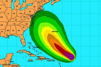
The latest advisory from the National Hurricane Center and analysts at NASA's Goddard Space Flight Center have included probabilities that Hurricane Katia could potentially make landfall in the New York City region.
Katia's path is still unpredictable due to other weather systems affecting it development. Presently drier air and wind shear are slowing the growth and advancement of Katia. According to the NHC, Katia is “just barely a hurricane” with sustained winds marginally above 74 mph.
Meanwhile, Katia is currently packing maximum sustained winds near 75mph (120kph). Hurricane force winds extend outward up to 35 miles (55km) from the center. Tropical Storm force winds extend outward of up to 175 miles (280 km), mainly to the north and east of the center.
After appearing to be headed for the open Atlantic mid-week, perhaps threatening only Bermuda, the latest computer models for Katia push the storm further south and put it as a major hurricane 700 miles east of West Palm Beach on Wednesday.
There remains a lot of time for things to change, but if the models continue this trend it could be a threat to the U.S. East Coast, with a swath from eastern North Carolina to New England still picking up the pieces from Hurricane Irene.
Also, the forecast models are tracking Tropical Storm Lee in relation to Katia’s future tracking scenarios. If the remnants of Lee move far enough into the Northeast US region, they could push Katia’s trajectory further east, away from the US coast-line or act to diminish Katia’s intensity. Forecasters say a clearer picture is likely to emerge Monday or Tuesday.