Tropical Disturbance Over Florida Raises Concerns of Development in the Gulf
Florida is once again under the meteorological spotlight as a broad area of low pressure—currently drifting over the Florida Panhandle—threatens to bring heavy rainfall, flash flooding, and possibly develop into a tropical depression later this week.
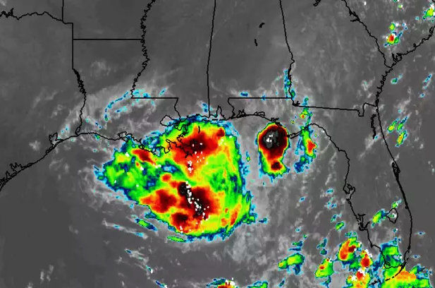
Known officially as Invest 93L, this tropical disturbance is moving slowly westward and has already begun to saturate parts of northern Florida with persistent showers and thunderstorms. The National Hurricane Center (NHC) is closely monitoring the system, giving it a 40% chance of developing into a named storm—possibly Tropical Storm Dexter—within the next seven days.
Although the system remains disorganized, meteorologists caution that once it enters the northeastern Gulf of Mexico, conditions could become more favorable for tropical development. If so, coastal areas along Florida’s Gulf Coast, as well as parts of Alabama, Mississippi, and Louisiana, could face increased risks from heavy rainfall, gusty winds, and coastal flooding by Thursday or Friday.
In the meantime, flash flood warnings are in effect across northern Florida, especially in low-lying and poorly drained areas. The central and southern regions, including cities like Miami, continue to experience daily thunderstorms and high humidity, a pattern that is expected to persist through the weekend.
Even if the system fails to reach full tropical storm status, its wide circulation and moisture content could still result in significant flooding impacts across a large swath of the southeastern United States. Residents in affected areas are advised to monitor NHC updates, avoid unnecessary travel during heavy rain, and review basic emergency preparedness plans.
As always during hurricane season, conditions can evolve rapidly. All eyes remain on Invest 93L as it makes its slow journey into the warm waters of the Gulf, where nature could take a more serious turn in the days ahead.