Danny Should Miss Florida, but There Are No Certainties about its Track
The tropics, so far this season, have been rather quiet. Even though Danny is the fourth named storm of the season, they have all been relatively weak and somewhat disorganized tropical storms. None of the previous named storms this season even had a chance of developing further.
Well, Danny may.
During Wednesday morning, a lot of dry air was getting wrapped into the circulation, and that disrupted the convection around Danny’s center. That dry air at the moment, and for the next two to three days, is the only inhibiting factor toward development. If Danny can fight the dry air, it may become a hurricane before reaching the islands of the Eastern Caribbean.
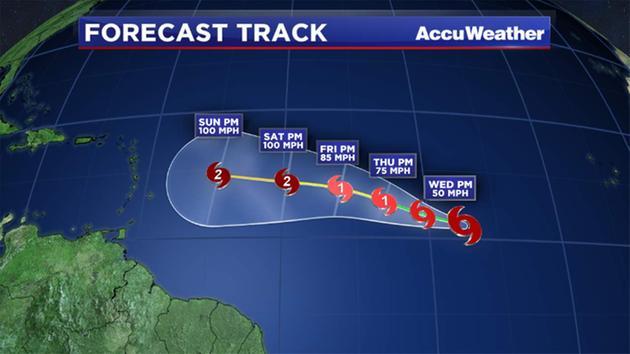
Danny is following a very typical track for a storm located in that part of the Atlantic Basin. It is heading west-northwestward, and should for the next four to five days. After that, the forecast track and intensity become a bit of a challenge.
The atmospheric conditions in the Caribbean are not terribly favorable for further development. In fact, some reliable models indicate that the very hostile upper air conditions will remain in place while Danny approaches. If that scenario holds true, then Danny could just fizzle out.
There is an area of less hostility to the north of the easternmost islands of the Caribbean. If Danny can get there, it may maintain its intensity and even strengthen.
Here is the good news: Either scenario means a likely miss of Florida or even the United States. The weaker scenario would have it benignly move through the Caribbean, likely as an open wave by the middle of next week. A stronger Danny would likely turn north, well east of the Bahamas, and eventually move out to sea.
It is important to understand that since Danny is continually evolving, as are the upper air conditions around the storm, changes to the forecast thinking may take place. Just know, that we here at Bay News 9 are on top of it.